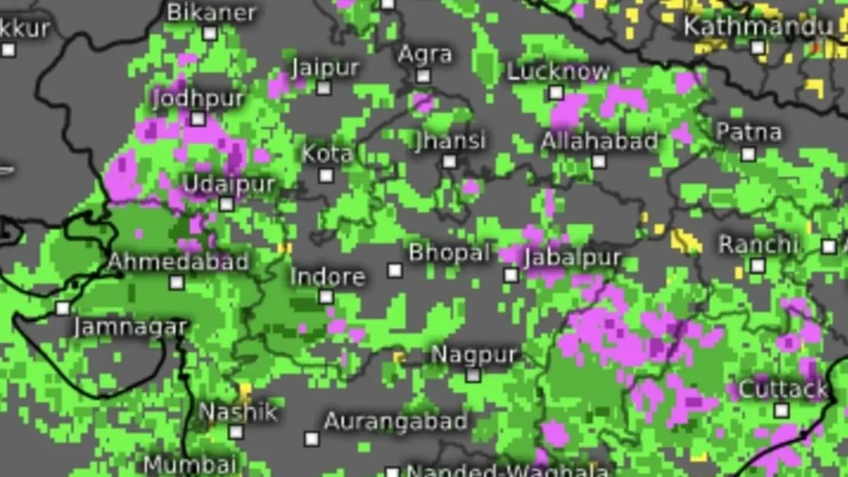
Heavy to very heavy rain (in green and purple) is forecast for Odsha, Chhattisgarh and parts of Gujarat and East Rajasthan until Thursday as monsoon holds strong over northern parts of India.
| Photo Credit:
www.meteologix.com/in
India Meteorological Department (IMD) predicted extremely heavy rainfall (20 cm+) at parts of over East Rajasthan and the ghat areas of Madhya Maharashtra on Wednesday even as the causative low-pressure area over south Jharkhand weakened.
The ‘low’ lay lately as a cyclonic circulation on Wednesday, but its rain-generating hardly impacted capacity as it was ensconced with the the confines of monsoon trough tracking from Rajasthan across Bikaner; Banasthali; Shivpuri; Siddhi; Chaibasa; and Digha before dipping into east-central Bay of Bengal, pregnant with possibilities for triggering another ‘low.’
Active monsoon conditions
The monsoon trough lies to the south of its normal alignment and is set to continue to preside over an active to intense rainfall regime over Central India, North-West India and parts of the West Coast while being being quieter over North-East India; interior north peninsula; and South Peninsula. Rain deficits in parts of theses areas may linger for some more time.
A cyclonic circulation popped up over north-east Assam on Wednesday, likely prompting weakening of existing ‘low’ over south Jharkhand in the first place. A secondary east-west trough lay superimposed over monsoon trough from south-east Rajasthan to north-west Bay of Bengal across central Madhya Pradesh; north Chhattisgarh; south Jharkhand; and plains of West Bengal.
Successor ‘low’ likely
Numerical model predictions hint the circulation ramping as a low-pressure are as it moves over Central India. It will be head towards central Madhya Pradesh over a period of next 10 days (until July 12 till when forecasts are available), marshalling heavy monsoon flows across both from the Bay of Bengal and the Arabia Sea, setting off flooding rains over parts of East-Central India.
Central India rains
Very heavy rainfall has been forecast over Madhya Pradesh for five days from Wednesday; over Chhattisgarh and Odisha on Saturday and Sunday as the circulation over north-east Assam moves slowly west into East and Central India. The IMD said Isolated heavy rainfall is likely over Madhya Pradesh; Vidarbha; Chhattisgarh; and Odisha for seven days from Wednesday; and over Bihar; West Bengal; Sikkim; and Jharkhand for five days as the circulation gathers further traction.
Heavy over West India
As for West India and parts of West Coast and adjoining interior peninsula, heavy to very heavy rainfall is likely at Konkan and Goa; ghat areas of Madhya Maharashtra and east Gujarat while it would be heavy over Saurashtra and Kutch during next seven days. In the South, very heavy rainfall has been predicted over Kerala and Karnataka on Wednesday.
Elsewhere in the South, isolated heavy rainfall is likely over the deficit regions of Coastal Andhra Pradesh and Telangana on Wednesday; over Kerala and Mahe for four days from Wednesday; and over Karnataka for six days. Strong surface winds with speed reaching 40-50 km/hr have been warned over entire South Peninsula during next seven days.
Published on July 2, 2025